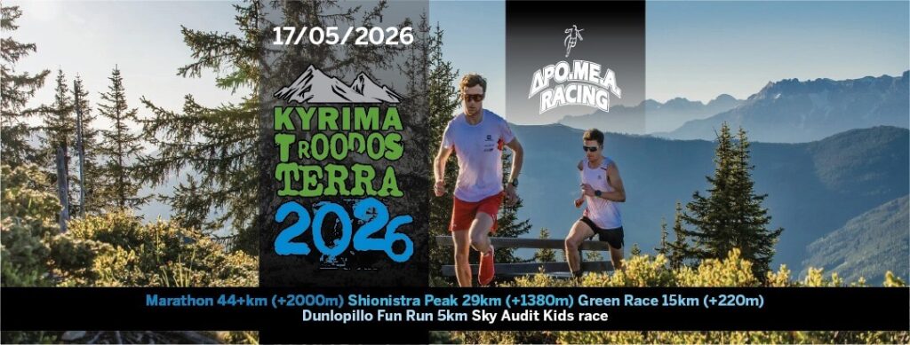
EVENT DETAILS
- Event Date / Time: 17/05/2026 – 5:00 am
- Location: Troodos
- Capacity: 770
- Registrations Close: 13/05/2026
Dro.Me.A. Racing Club is organizing for the 17th year the mountain running race “Troodos Terra 2026.” The main sponsor of the event is KYRIMA Smart Electrical & Lighting. The event will take place on Sunday, May 17, 2026, starting and finishing at Troodos Square.
The event will include the following races:
- 05:00 am – Marathon 44+ km (+2000m) for experienced runners aged 18 and over. Trail shoes are mandatory. The participation fee is set at €50.
44+ km Route Update:
This year, a section of the 44+ km Marathon route has been modified following a recommendation by the Department of Forests. Specifically, the segment between 26 km and 30.4 km has been changed and now follows a new course. Athletes are kindly requested to familiarize themselves with the updated route in advance. Failure to follow the new route may result in disqualification. – The updated map and GPX file are available on the official website and the registration platform.
- 06:00 am – Shionistra Peak 29 km (+1380m) for experienced runners aged 18 and over. Trail shoes are mandatory. The participation fee is set at €35.
- 08:00 am – Green Race 15 km (+220m) for runners aged 18 and over. Trail shoes are mandatory. The participation fee is set at €20.
- 08:10 am – Dunlopillo Fun Run 5 km for runners aged 18 and over. Trail shoes are mandatory. The participation fee is set at €15.
- 10:40 am – Sky Audit Kids’ Race 600 m for children from 5 up to 12 years old. The registration fee is €5.
Registrations for the races will be accepted ONLY through the website https://getyourtickets.eu/event/troodosterra2026 until Wednesday, 13 May 2026, and registration fees are non-refundable.
- Runners who register by April 30, 2026, will have their names displayed on their bib number.
- Runners who register by May 05, 2026, will have the opportunity to collect their participation package from the ACS COURIER of their choice.
There will be symbolic awards for the first six (6) men and the first six (6) women in the 44+ km and 29 km races.
In the other distances – 15 km, 5 km, and Kids’ Race – there will be symbolic awards for the first three (3) men and the first three (3) women.
#DroMeARacing #DroMeA #TroodosTerra #KyrimaTroodosTerra
RACE INFORMATION
MARATHON 44+km. (+2000m)
Race route information:
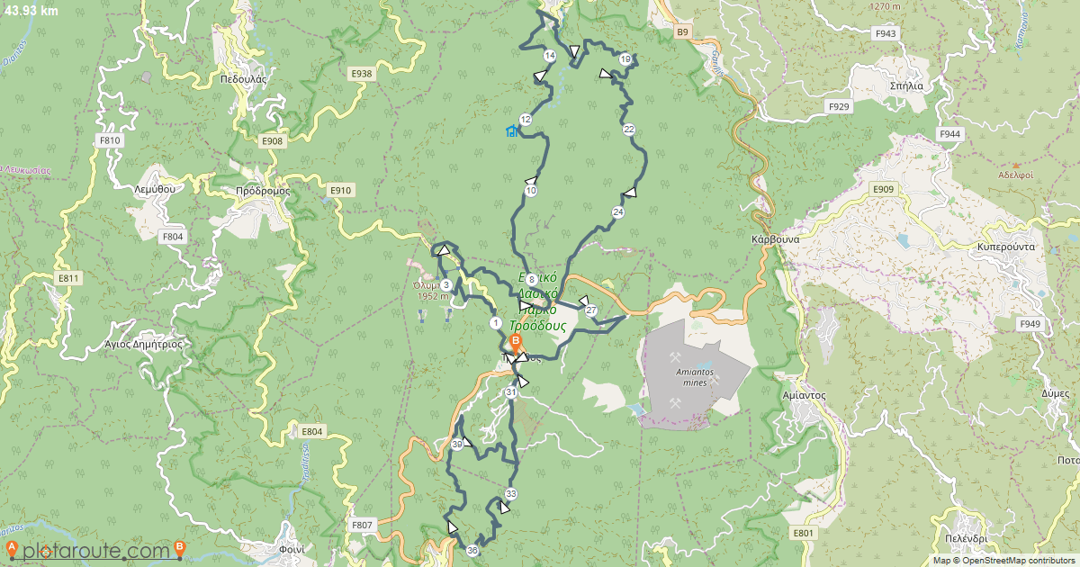
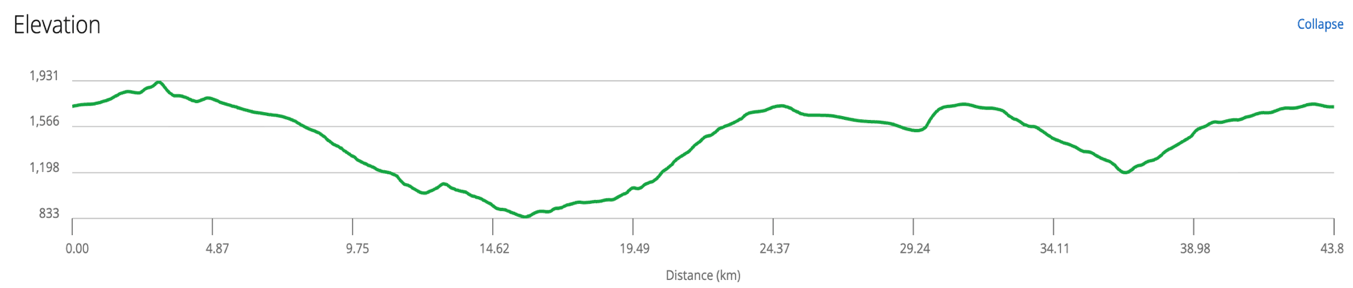
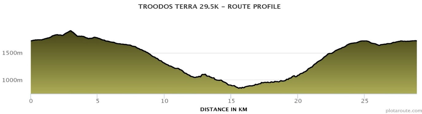
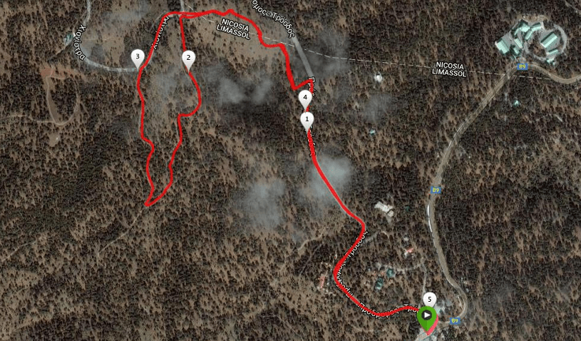
The runners, after the start at Troodos square, will be heading north, following the road (asphalt), towards Olympus. Around the 1.2 km mark, the runners will make a left turn and enter the pathway for about 1.2 km. At the 2.5 km mark, they will cross the asphalt road, which leads to Olympus, and they will enter the Artemis trail, where, they will follow an uphill path, reaching the peak of Olympus (3.5 km – 1st check point). From this point, the runners will descend from the ski slope for about 300m and then take a right turn, entering a dirt road for about 200m. Thereafter, they will make a right turn and enter the Atalante path, which takes them back to Troodos square and the area where an army camp is located (asphalt, 7th km). Following the asphalt road for 200m, the runners will turn left and follow the dirt road for 600m. Then, turning right, they will enter the pathway towards Kannoures. Following a downhill direction towards Ayios Nikolaos, the runners will cross the river, multiple times, which is found along the pathway, until the entrance to the dirt road, located at around the 12.5 km (1st refueling station). Continuing the descend for about 2 km, the runners will reach Ayios Nikolaos at the 14.5 km mark (asphalt). At this point, they will make a right turn and at around 500m, they will turn right again, entering the pathway. Passing in front of the fish farm and crossing the river again, the runners will follow the dirt road up to the 19th km, where they will find the 2nd refueling station. This is also the cut-off point for 3 hours. Thereafter, the runners will enter the pathway, Mnimata ton Piskopon, where they will follow an upward direction up to the 21st km (blue barrel with water). The runners continue the uphill direction and enter the dirt road up to the asphalt road at the 25th km. They turn right onto the road until they reach the main Nicosia–Troodos Road. They then turn right again and continue for approximately 500 meters to Xylovrysi. About 100 meters after Xylovrysi, they will cross to the left onto a dirt road heading toward Armyrolivado at 28.5 km, where the 3rd water station and checkpoint are located. They then turn right into the dirt road in the direction of the Giant Aoratos. At 30.4 km, they turn right, where a steep and demanding uphill section begins: 600 meters long with a gradient exceeding 20%. This climb starts in front of the protected 480-year-old tree Giant Aoratos and finishes at Troodos Square at the 31 km, where the 4th refueling station is located. This same point also serves as a cut-off point (6 hours). The runners continue on the Troodos–Platres asphalt road and at the round-about in front of Troodos Hotel, they make a slight left turn, heading towards the British Army camp after about 1 km. Crossing the dirt road for about 1 km, the runners will enter the Pouziari pathway at the 33.3km. This pathway is downhill and reaches up to Platres, in front of the ‘Psilo Dentro’ restaurant, at the 37.7km, where the 5th refueling station and checkpoint are located. Then, the runners will cross and ascend for 3 km the demanding but beautiful, whole-green Kalidonia pathway, crossing the river (where abundant drinking water flows) numerous times, until they enter the dirt road at the 40.6 km. After they exit of the pathway, they turn right following the dirt road, which has a slight uphill gradient until the Troodos central square, where the finish line is located.
The Marathon 44+km race route in GPX file format.
You can download the route in GPX file format. Click below.
![]()
Υψομετρική / Elevation Chart
SHIONISTRA PEAK 29km. (+1380m)
Race route information:
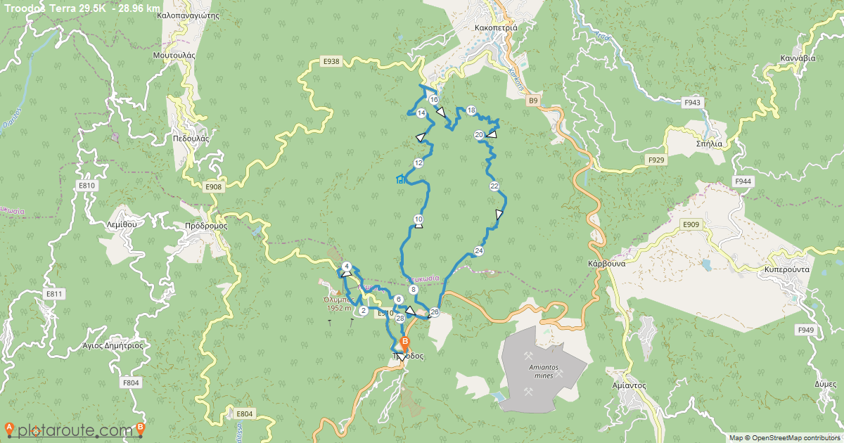
The runners, after the start at Troodos square, will be heading north, following the road (asphalt), towards Olympus. Around the 1.2 km mark, the runners will make a left turn and enter the pathway for about 1.2 km. At the 2.5 km mark, they will cross the asphalt road, which leads to Olympus and they will enter the Artemis trail, where, they will follow an uphill path, reaching the peak of Olympus (3.5 km – first check point). From this point, the runners will descend from the ski slope for about 300m and then take a right turn, entering a dirt road for about 200m. Thereafter, they will make a right turn and enter the Atalante path, which takes them back to Troodos square and the area where an army camp is located (asphalt, 7th km). Following the asphalt road for 200m, the runners will turn left and follow the dirt road for 600m. Then, turning right, they will enter the pathway towards Kannoures. Following a downhill direction towards Ayios Nikolaos, the runners will cross the river, multiple times, which is found along the pathway, until the entrance to the dirt road, located at around the 12.5 km (1st refueling station). Continuing the descend for about 2 km, the runners will reach Ayios Nikolaos at the 14.5 km mark (asphalt). At this point, they will make a right turn and at around 500m, they will turn right again, entering the pathway. Passing in front of the fish farm and crossing the river again, the runners will follow the dirt road up to the 19th km, where they will find the 2nd refueling station. This is also the cut-off point for 3 hours. Thereafter, the runners will enter the pathway, Mnimata ton Piskopon, where they will follow an upward direction up to the 21st km (blue barrel with water). The runners continue the uphill direction and enter the dirt road up to the asphalt road at the 26th km. Then, they turn right towards the street and passing successively, by the wooden-faucet and the army camp, they turn right (the same point they had passed by at the 6th km). After 500m, into the dirt road, they turn left so as reach the Troodos square (parking area) at the 29.5 km.
The Shionistra Peak 29km race route in GPX file format.
You can download the route in GPX file format. Click below.
![]()
Υψομετρική / Elevation Chart
GREEN RACE 15km (+220m)
Race route information:
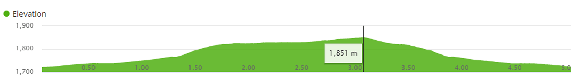
The race distance is 15 km with a +240 m altitude gain. The terrain will be 1,7 km asphalt and 13,6 km through natural trails (1,5 km in the Artemis and 10 km in the Atalante trails), 1,2 km in the skiing route and 0,6 km through forest road. The start will take place at Troodos square (altitude 1724 m). After the start the runners will follow the main road from Troodos to Prodromos. After about 1,2 km the runners will turn left in the forest road where after 500 m they will reach the entrance of the Artemis trail. After the 3rd km at an altitude of 1852m, there will be 300 m downhill on asphalt where, after the runners make a left turn they will run through a part of the Artemis trail. In about 500 m, the runners will find on their left the skiing route (connection piste 1- Hera). There will be a 700 m uphill part with a high incline, which leads the runners to the peak of Olympus at an altitude of 1952 m, Cyprus’ highest point. There, the runners will be at the 4.5 km mark of the race and will pass through the first check point. Following this, there will be a 500 m sharp downhill (which should be approached with caution), from the skiing route of north face b. The runners, after passing the skiing center on their left will end up on asphalt terrain, where after about 200 m they will reach the entrance of Atalante trail and the 1st refuelling station will be found (5.2 km mark). The route continues through Atalante trail for 9,8 km until the finish in Troodos square. The Atalante trail has no significant altitude changes, but it is very technical. At the 10,7 km mark the runners will find the 2nd and last refuelling station, in front of the entrance of the old mine. At this point the runners will pass through the 2nd check point at 1749 m of altitude. 100 m prior to the 12th km there is a natural spring with drinking water.
The Green Race 15km route in GPX file format.
You can download the route in GPX file format. Click below.
![]()

Υψομετρική / Elevation Chart

DUNLOPILLO FUN RUN 5km
Race route information:
The race is ideal for beginner mountain runners and there will be no cut-off time. The race distance is 5 km with a +130m ascend. The terrain is 3 km on asphalt and 2 km through the natural trails (part of the Artemis trail). The start and finish will be held at Troodos square. After the start of the race the runners will follow the main road from Troodos to Prodromos. At the 1200 m point they will make a left turn into the forest trail, where, after about 500 m they will reach the entrance of Artemis natural trail. At the 3rd km, which is the highest point in the race (1852 m), there will be a refueling station. The last 2 km are downhill, mainly on asphalt with only about 500 m through forest trails (between 3.3 – 3.8 km).
The Fun Run 5km race route in GPX file format.
You can download the route in GPX file format. Click below.
![]()
Υψομετρική / Elevation Chart
SKY AUDIT KIDS’ RACE 600m
Race route information:
The race is suitable for children aged 5-12. Young runners will have the opportunity to run a distance of 600m and experience the magic of sport in the beautiful green Troodos mountains. The start and finish line will be at Troodos Square.